
A New Map of Georgia, with Part of Carolina, Florida and Louisiana by Emanuel Bowen, 1744
Share This


Print This
Email This
European Political Agendas Running Amuck in a New World South
Not long ago I was at a family reunion deep in the rural countryside when I received a text message from a cousin of mine asking where the place was located. He could not find it on any map or using any searchable GPS or other navigational system. Using my smartphone, I was able to send him exact coordinates of my current location, which then allowed him to use his phone’s GPS to direct him to those coordinates. Within the last decade, GPS and applications like Google Maps have transformed the way humans navigate and think about the landscape and environment around them. Current technology is governed and driven by raw data, concerned primarily with pinpoint accuracy. However, long before technological advancements of GPS navigation and digital map applications, the art of cartography was much different. To be fair, accuracy was important, but the purpose of these early maps was rarely for navigation. Accuracy was less important than the opportunity maps represented to support the bias and agenda of the cartographer or, more important, the one funding the cartographer. Below I’ll discuss two maps, both created in approximately the same time period and depicting the same geographic area, but which offer two very different perspectives.
Carte de la Louisiana et du Cours du Mississippi, created by Guillaume Delisle and published in 1718, is a one of the most significant maps of its time. Delisle, who was chief royal geographer for France, compiled the map from the reports of French explorers as well as from his father’s previous drawings, who was also a prominent French cartographer. Using these numerous sources, Delisle was able to get many physical details right, some for the first time. It is the first accurate depiction of the mouth of the Mississippi and the Gulf Coast. Over time, his work became the main source for later cartographers dealing with this area. Both the Missouri and the Rio Grande Rivers are shown in a fairly accurate manner but are given earlier names. The Missouri, however, is shown as flowing around the northern end of the Rocky Mountains. In addition to these major physical features, the extent and amount of seemingly minor details crowded into this map is phenomenal. There are hundreds of place names including cities, forts, rivers, lakes, and mountain ranges. The routes of early explorers are included as well as the locations of Native American towns. One could easily get lost for hours exploring every inch of this map. Despite the many accuracies and the amount of effort to achieve correct details, taking a step back and looking at the map as a whole, the overt political overtones become obvious and Delisle’s political agenda is revealed.
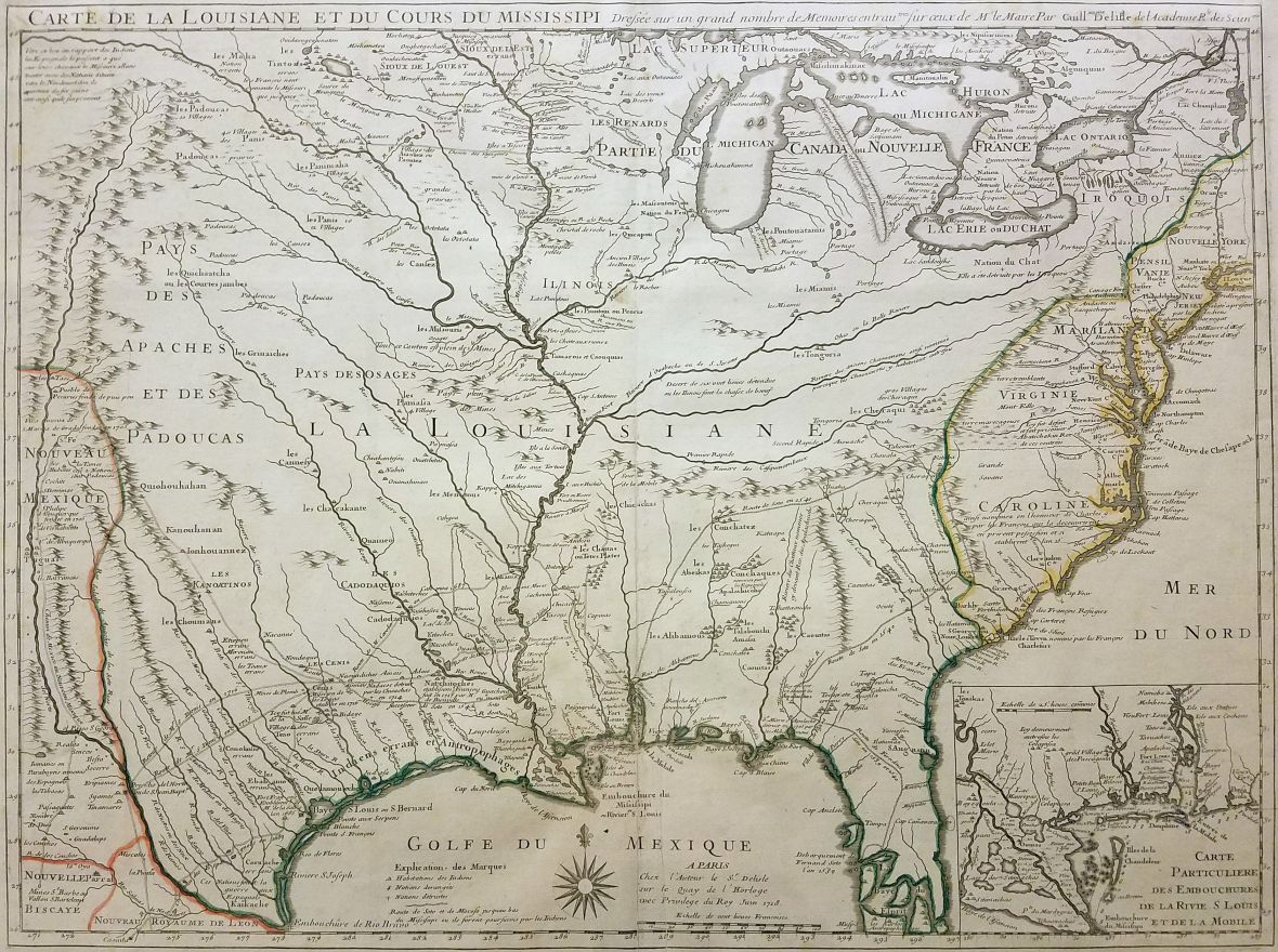
Carte de la Louisiana et du Cours du Mississippi by Guillaume Delisle, 1718
In large letters stretching across the center of the map is written “La Louisiane” the French New World territory. Slightly smaller, yet still prominently featured, is “Parte du Canada ou Nouvelle France” in the north. Other European territories are greatly circumscribed. French land pushes far past the Appalachians and deep into Texas and Florida, land claimed by Britain and Spain respectively. He inaccurately asserts that Charles Town was the failed French outpost Charles Fort from the 1650s. He also claims Carolina was named for French King Charles IX instead of Charles I of England. Carolina also does not extend to the Savannah River. Delisle’s map makes a very powerful display of French dominance in the New World supporting French authority and lending legitimacy to their claims. However, as we’ll see below, their chief rivals, the English, were equally effective in this tactic.
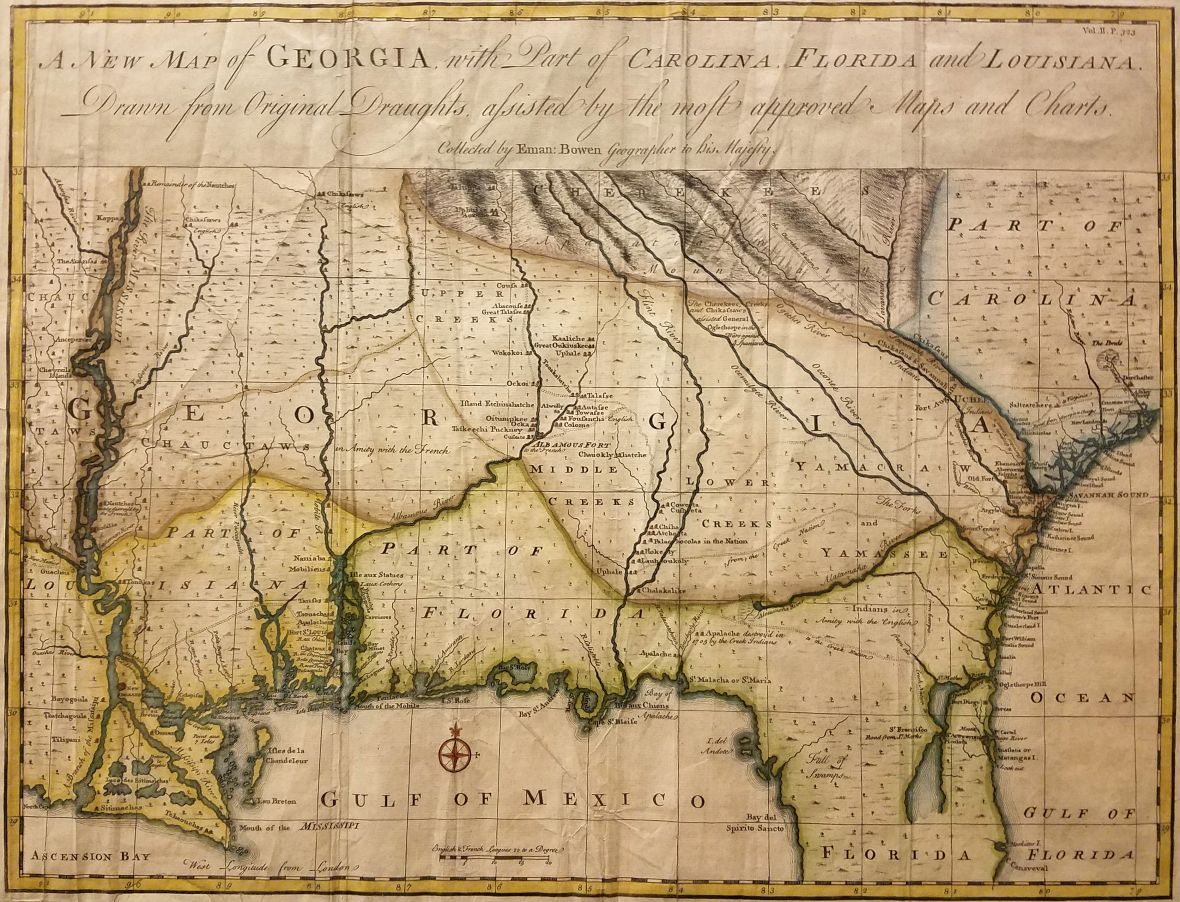
A New Map of Georgia, with Part of Carolina, Florida and Louisiana by Emanuel Bowen, 1744
Emanuel Bowen produced A New Map of Georgia, with Part of Carolina, Florida and Louisiana in 1744. It is considered one of the finest Georgia maps ever produced. It was published in John Harris’s Navigantium atque Itinerantium Bibliotheca, or Complete Collection of Voyages and Travels. The atlas was originally published in 1705, but a chapter was added on the history of Georgia in the 1744–48 and 1764 editions with this map included. Much like Delisle, Bowen must be credited for the amount of detail and accuracy he achieves, especially along the Atlantic coast and his capture of Native American settlements and their trading paths. He also indicated whether the tribes are friendly to the English or the French. One interesting error, though, is the depiction of the Chattahoochee and Flint Rivers. The Flint is depicted as extending into the Appalachians instead of the Chattahoochee. This particular copy features superb hand coloring, enhancing its artistic merits. Indeed, early cartography focused on the decorative elements with embellished compasses and cartouches and very little white space. Cartographers often filled oceans and parts that were not well known with drawings of animals, boats, and even sea monsters. Maps were intended for display and usually not for traversing trails or navigating rivers. However, decorative flourishes do not conceal the political nature of this map.
Just as Delisle did with Louisiana, Georgia is written in large letters across the center of the map, at first glance nearly encompassing the entire Southeast. Upon further inspection, Louisiana, Florida, and even Carolina are all given their dues. However, Georgia is certainly the centerpiece. It extends past the Appalachians, and Bowen is even so bold to cleverly slip the “G” on the other side of the Mississippi. Britain did not gain the territory between the Mississippi River and the Appalachians until after the French and Indian War in 1763. Furthermore, they had no real claim on land west of the Mississippi. That would be retained by France until 1803 when it was sold to the United States as part of the Louisiana Purchase.
When compared, these two maps contrast starkly. One paints a vision of French dominance and the other English dominance. They both serve to advance political agendas and legitimize imperial claims. They scream “look how great our empire is!” It is easy to imagine this map prominently displayed in a government official’s office, perhaps a diplomat’s or ambassador’s, as they deliver messages of national greatness to others. These are not just “one of a kind maps” either, they were produced in large quantities for sale and distribution, helping to spread the narrative of nationalism. As opposed to a strictly verbal narrative, these published documents exert a certain level of concrete authority as well. Most would not question the accuracy or bias of maps, especially people today who are used to maps strictly generated from digital data. They accept that maps are accurate and always have been. This is a reminder that no matter the source, it is always best to approach information with a critical eye.
The maps referenced here are part of the J. Kyle Spencer collection at Columbus State University, Columbus, Georgia. The collection consists of nearly two hundred maps that range from the late 1500s to the late 1800s. They depict primarily the Southeast and document the emergence and evolution of the American colonies, specifically Georgia, and the formation of the United States as a whole.