


Separation and Belonging
The greatest thing is not to possess, but to belong.
—Leader, Strike at the Wind!
As a child in the 1950s, my mother lived for a time with her parents and siblings on her grandparents’ twenty-five-acre tobacco farm, a two-and-a-half-mile walk from the small town of Pembroke, North Carolina. Pembroke was, and still is, the cultural and political seat of the greater Lumbee community. Lumbees are Indigenous to the area around present-day Pembroke. We belong to the surrounding land that is now part of Robeson County, and we belong to the encompassing Coastal Plain—a broad swath of land sandwiched between the rolling Piedmont and the Atlantic Ocean.
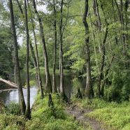
My mother’s upbringing resembled that of many Lumbee children during that period: no running water, legalized segregation, and a community defined, in part, by its relationship to water. Her particular community, Sandy Plains, spread out across high, flat ground that was wedged between Bear Swamp and Moss Neck Swamp. Both swamps are tributaries of the Lumbee River, which rises in the uppermost reaches of the Coastal Plain and flows more than 100 miles before merging with several other streams and emptying into the Great Pee Dee River near the Atlantic Ocean. The Lumbee River and its tributaries are flanked by wide floodplains—swamps dense with bald cypress and black gum. Beneath the tree canopy lies an understory of intertwining shrubs, vines, and herbs. These swamps dominate the landscape for tens of miles in every direction surrounding Pembroke.
Sandy Plains, a collection of small farms and a nearby Methodist church, was aptly named because it occupied relatively dry and well-drained land between the two swamps. The terms “dry” and “well-drained” are relative, however. The eponymous plains with their sandy soils sit atop a layer cake of sediments that represent a geological record of the repeated advance and retreat of ocean waters over a three-million-year period. Importantly for the residents of Sandy Plains, the properties of those layered sediments determine whether and where water drains or pools after a storm.
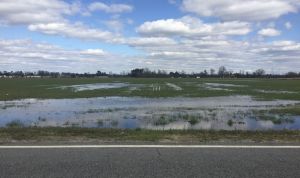
Flooded crops fields. Photograph by Ryan Emanuel.
A few times each year, intense or prolonged rains overwhelm the landscape and utterly saturate the underlying sediments. When this happens, shallow ponds form across the crop fields and yards of Sandy Plains. During these wet times, Bear Swamp and Moss Neck Swamp swell beyond their floodplains, inundating the outer rows of crops and fringes of yards. Usually, such floods are only a minor nuisance to people, but they can pose a larger challenge when it is time to plow, harvest, or mow. Above all, the periodic inundation is a reminder that water—not dry soil—is nature’s preferred medium in these parts. Sandy Plains exists at the discretion of the surrounding swamps.
In the first two decades of the twentieth century, Sandy Plains and countless other communities in the region came to rely on vast networks of artificial canals and ditches to permanently drain swamps and other wetlands. The US Department of Agriculture and other government agencies promoted artificial drainage as a solution to nuisance flooding and also as a way to increase the overall amount of land under crop cultivation. Lumbee people and many others were assured by agricultural agents that ditches and canals would eliminate, once and for all, the flooding that stymied their efforts to plant and harvest. Government officials and timber companies also speculated that by extending canals and ditches deep into swamp forests, loggers could easily fell and extricate any remaining old growth trees that had survived prior waves of clear-cutting. In fact, timber companies had been eyeing Robeson County’s remaining swamp forests since at least the 1880s. A note published by Scientific American in 1888 lays out, with clinical precision, one company’s plan to deforest swamplands along the Lumbee River: “When the timber shall be exhausted along the main ditch, spur canals will be dredged out, and thus more cypress reached. This process will go on until the timber is all cut, and the entire swamp converted from noisome, malarious ooze into cultivable land of the richest kind.”[1]
By 1920, these plans had been executed, more or less, throughout Robeson County. The resulting landscapes had been ditched, drained, and cleared of old growth trees according to a system of values that commodified timber and soils dry enough to raise crops. Canals lined roads and fields throughout the region. Communities like Sandy Plains grew with the availability of newly drained land. In a generation, wetlands had become croplands with only periodic reminders of their watery past.
Thus, by the time my mother came along, Sandy Plains had been surrounded for decades by deep canals and smaller ditches. Arrow-straight paths followed ditches to make shortcuts from one farmhouse to another. Ditch water, stained dark with organic matter leached from the surrounding soils, collected in canals that were as large as twenty feet wide and ten feet deep. These canals were the largest water bodies in Sandy Plains, and they created obstacles that separated homeplaces and families from one another. My mother’s family overcame one such obstacle by building a footbridge across the wide canal between the old wooden house where my mother lived and a relative’s farm. The footbridge was not much to speak of—two pine logs, laid side-by-side, spanning the dark water at the bottom of the canal.
Early one spring evening, my grandmother sent my mother—the eldest child—to fetch her Uncle Walter from next door to help with a chore. My mother dutifully made for his house, following the well-worn path through the sandy yard, across a hard-packed driveway, and over the two-log bridge. She returned a short time later, having completed her mission, and announced that Uncle Walter would be along presently.
Later that night, however, Uncle Walter had not arrived. My grandmother set out into the darkness with a kerosene lantern to check on him. As she approached the log bridge, the flame of her lantern illuminated an unusual shape in the water below. My grandmother drew closer and discovered the body of Uncle Walter, who had fallen into the canal while crossing the bridge earlier that evening. He apparently drowned or succumbed to a heart attack as he struggled in the dark water. Uncle Walter’s tragic end emphasizes the enormous size of canals that served as both infrastructure and obstacle.
By my childhood, the ubiquitous canals and ditches seemed to be primordial landmarks—ancient as the Coastal Plain itself. In reality, however, they were less than a century old. Uncle Walter would have seen them dug in his lifetime, and it is possible that he even assisted in their construction. I never knew Uncle Walter, and my grandmother had long since moved from the old wooden house into a new brick house across the field. But I knew the old homeplace and the canal where it happened. I also knew that it fed into Moss Neck Swamp, which drained into Bear Swamp, which flowed onward to the Lumbee River.
As a child in the 1980s, I paid close attention to the arrangement of roads, bridges, canals, and swamps around Robeson County. Although my parents raised me in Charlotte, two hours west, we were firmly tethered to Lumbee homelands in Robeson County by US Highway 74. The highway was a 100-mile-long asphalt umbilical cord, kinked with dog-leg turns and constricted by traffic lights. It was a much different road than the nearly completed freeway that exists today. The two-hour drive between Charlotte and Robeson County was a slow, ceremonial re-entry into a space that I knew was sacred even before I knew what sacred meant.
Driving to Robeson County was synonymous with going home, and part of being at home—in addition to rich food, doting elders, and long church services—was to be surrounded by water. Much of that water was hidden in the shadowy swamps that we crossed en route from one homeplace to another. These regular drives through Robeson County were nested within each larger trip from Charlotte. My parents referred to these circuits as “visiting,” and each round could easily involve a half dozen stops scattered across a county nearly the size of Rhode Island.
In retrospect, visiting was a driving tour along the limbs of my family tree. Families exchanged news, gifts, and well wishes across the limbs and branches, and I slowly learned that each stop represented a node in two different networks: one defined by kinship and another by miles of rural asphalt.
As we drove seemingly endless loops around Robeson County, I also encountered a third network—a network of water. Country roads typically ran parallel to swamps and ran along high, interstitial ground until—out of opportunity or necessity—the pavement dipped to cross a swamp or the Lumbee River itself. The water crossings were accompanied by a change in scenery from crop fields to dense, thick forest. Most crossings occurred at low, concrete bridges, whose railings gave me a brief glimpse of the dark water below. In good weather, I sometimes caught a glimpse of people fishing or swimming.
I also noticed the canals that traversed the landscape in straight lines and only seemed capable of making ninety degree turns. Gradually, I came to realize that the river, swamps, canals, and ditches were part of a larger system of water on the move—a simple observation, but one that gave my young mind a way to organize a landscape that I knew was integral to my identity.
Today, as a water scientist and as a Lumbee person, I continue to think about the watery landscapes of my ancestral home. On one hand, I am grateful that our relationship with our namesake river has persisted for so long. The river features prominently in our stories about refuge, survival, and resistance. Even though some of our ancestral knowledge about the river lies dormant or has been lost altogether, I respect the persistence and creativity individuals who work to reawaken knowledge about foodways, dugout canoes, and more.
On the other hand, as a scientist whose work involves tracking the pace and impacts of human changes to the environment, I am concerned about the trajectory of change experienced by the Lumbee River and its watershed in recent decades. The coming of gas pipelines, the rise of industrial livestock facilities, and the ongoing drainage of wetlands have radically transformed our homeland in a few short decades. Pollution, unsustainable development, and other destructive activities have indelibly altered the flow and quality of water in a place that Lumbee historian Malinda Lowery describes poetically as “water and soil, two perfect opposites flowing together since ancient times.”[2] In doing so, these activities threaten the ability of Lumbee people to maintain our collective relationship to our watery home on the Coastal Plain.
These harmful activities take place against the backdrop of climate change, further compounding the destruction. For example, engineers designed the canals and ditches of Robeson County by reviewing rainfall data collected around the turn of the twentieth century. They also consulted with area residents, who reported that the worst flooding in at least 100 years occurred in 1901, when a wet spell brought twelve inches of rain to the Lumbee River watershed in a span of one month. Assuming that the 1901 floods represented the most extreme scenario, the engineers set to work designing canals and ditches that were large enough to accommodate such an event.[3] For decades thereafter, the ditches and canals largely served their purpose, and they became part of the everyday scenery of Robeson County.
In October 2016, Hurricane Matthew brought twelve inches of rain not in one month, but in a mere twenty-four hours. In 2018, Hurricane Florence brought more than seventeen inches of rain to the watershed in three days. The intensity and total amount of rainfall were unprecedented and far exceeded the conditions from 1901 that were used to design Robeson County’s drainage networks.
Flooding from the two hurricanes wreaked havoc on the entire region, but it was especially intense in communities that had been targeted for drainage projects a century earlier. Many community members blamed flooding on ditches and canals that had fallen into disrepair and become overgrown in recent decades. Local elected officials echoed their concerns and called for funding to revitalize aging drainage infrastructure.
While improved drainage may reduce some of the impacts of these storms, no canal system could have prevented the floods altogether. Ironically, however, canals and ditches do worsen floods downstream by short-circuiting the tendency of soils to absorb and hold onto rainfall before releasing it slowly into rivers and streams. Every improved drainage project upstream exposes a downstream community to greater flood risk; there is no free lunch.
Climate change increases the likelihood of future floods caused by storms like Matthew and Florence. In the coming years, Lumbee people and their neighbors in the Coastal Plain will need to think critically about the future of ditches and canals—infrastructure that is barely a century old but is deeply embedded into our homelands, economies, and stories. This infrastructure represents certain values and assumptions about water in our region—namely that people can control it, and its best place is somewhere else. In much the same way, we will need to think critically about the future of food and energy systems whose livestock facilities and pipelines are also embedded in our homelands.
The call to think critically about the future of food, energy, and water in a changing climate is nothing new. Neither is the warning that failure to do so threatens cultural ties between Indigenous peoples and their homelands. But the messages deserve to be repeated so long as the Coastal Plain remains a tangle of unsustainable practices that collectively separate people from place. Of course, the separation of people from place is not limited to the Coastal Plain, or to Robeson County, or to Indigenous Peoples in particular. But the separation is acutely felt here, and my recent book delves into the history, policy, and science of the unsustainable practices that have radically transformed the homelands of Lumbee people and their Indigenous neighbors. In it, I tell the stories of wetland drainage, fossil fuel infrastructure, factory farming, and climate change, and I draw out lessons for decision-makers and everyday people—Indigenous and non-Indigenous—about finding our collective way back from a separated condition.
We have a long road ahead and, in some ways, we are still traveling in the wrong direction if we care about protecting and restoring our connections to place. As I write, construction is about to begin on another gas transmission pipeline through Robeson County. It is part of a massive infrastructure build-out by energy companies in the region intent on profiting from fossil fuels for as long as they possibly can. While the infrastructure mainly serves gas-fired power plants generating electricity for cities and towns elsewhere, the communities and landscapes of Robeson County are fragmented by pipelines and saddled with the accompanying risks to health, safety, and quality of life.
I can see the surveyor’s stakes and flags marking the path of the new pipeline. It will pass through Sandy Plains, not far from the Methodist church where Uncle Walter and many of my ancestors are buried. Alone, the pipeline is just another obstacle. But it represents a long history of separating Lumbee people from the land and water to which they belong.
[1] Scientific American, “How to Utilize a Cypress Swamp,” Scientific American 58, no. 10 (March 10, 1888): 152.
[2] Malinda Maynor , The Lumbee Indians: An American Struggle (Chapel Hill: University of North Carolina Press, 2018), 4.
[3] Samuel H. McCrory and Carl W. Mengel, “A Report upon the Back Swamp and Jacob Swamp Drainage District, Robeson County, North Carolina” (Washington, D.C.: U.S. Department of Agriculture, 1912).
Wow! You are speaking truth to where we find ourselves in Debby’s aftermath. I am intrigued by your perspectives of how a changing climate can drastically change topography and even impact culture. Great read.